In 2021 we packed up our home in Ottawa, Ontario, and headed west to Victoria, British Columbia with our RV trailer. We had previously driven from Ottawa to Sydney, Nova Scotia (and back) for a holiday, so this was our opportunity to complete the rest of the Trans Canada Highway (excluding the section in Newfoundland and Labrador).
The Official Trans-Canada Highway Route
The Trans Canada Highway is a system of roads starting in St John's in Newfoundland and Labrador on Canada's eastern Atlantic coast, and ending in Victoria in British Columbia on the western Pacific coast. The whole route is just under 7,500km (4,650miles) and is one of the longest routes of it's kind in the world.
As a system of Provincial highways there are a number of parallel routes and off shoots (including routes to Prince Edward Island which we did in 2018 and up to Haida Gwaii some of which we did in 2022). The main route is generally considered to consist of Highway 1 in British Columbia, Alberta, Saskatchewan and Manitoba; Highways 17 and 417 in Ontario; Autoroutes 40, 20 and 85 in Quebec; Highway 2 in New Brunswick; Highways 104 and 105 in Nova Scotia; and Highway 1 in Newfoundland.
Our Trans-Canada Route
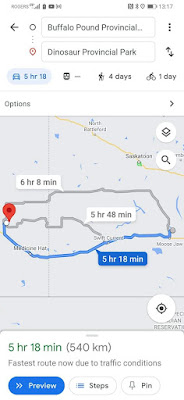
As you can see from the map above, we mostly stuck to the official Trans-Canada Highway route from Ottawa to Victoria, with a small diversion in BC because we wanted to visit the wine region of the Okanagan Valley.
Our Trans-Canada Equipment
We imported the Land Rover Defender from the UK and bought the RV during the COVID lockdown. COVID had made travel between the provinces extremely variable, and booking accommodation was almost impossible, however as we were moving as a military family we had a special exemption for inter-provincial travel. We decided that taking the RV would give us the most flexibility and allow us to pretty much self-isolate along the way, so it seemed like the perfect solution. As it turned out, our timing was great as we seemed to hit a low point of COVID infections in most of the country and in general travel restrictions continued to ease as we travelled west.
As we didn't want to sell in Ottawa and buy another vehicle in Victoria we also decided to take the Dodge with us. This meant driving in convoy the whole way, with Sarah driving the Dodge and Ridley driving the Landy. The advantage of this was that we could take a boy each and they couldn't fight!
Our Rocky Talkie radios proved invaluable along the way for keeping in touch, arranging fuel and rest breaks, pointing out interesting scenery or wildlife, and for directions when backing up the trailer.
We also took our Stand Up Paddleboards (SUPs) on the roof of the Land Rover, and used them on a number of lakes and rivers on the way. (Use the code ERRINGTONADVENTURES at Canadian Board Co for a discount!)
How Long Does the Trans Canada Highway Take?
If you ask Google how long it takes to drive from Ottawa to Victoria, it will tell you somewhere around 49 hours of driving. Depending on how many hours you want to drive in a day, and how many drivers you have per vehicle, you could in theory do it in 2-3 days. For our trip we took 17 days, we felt this gave us a good balance of short and long driving days, allowed us to stay 2 nights in a few places, and gave us 3 nights in Banff.
The Ottawa to Sydney section is another 17 hours or so. When we did this section in 2018, we did there and back in 14 days, but this included 3 days of work in Halifax. (We'll cover this section in a different post.)
Ontario
Day 1 - Ottawa to Petawawa
We weren't sure what time we were going to get away from Ottawa, so we decided on a short hop for the first day. We spent the first night at Black Bear Beach Campground near Petawawa. It's actually part of the military base, so is only available to military families, but it's a beautiful spot right on a beach on the Ottawa River. We had left our bookings a bit late for this part of our trip, so couldn't get a booking in Algonquin Provincial Park, but this would be a great alternative.
Day 2 - Petawawa to Sault Sainte Marie
Our second day was around 7 hours of driving and took us along the northern shore of Lake Huron, with some lovely views. We stopped for lunch in Sudbury at the MIC Canadian Eatery and Whisky Pub. Short for Made in Canada, they pride themselves on Canadian ingredients, only sell Canadian beer, and play Canadian music, as well as stocking over 80 Canadian whiskies!
We don't often stay at KOA campsites, but Sault Sainte Marie (known as 'the Soo'), was about the right distance for our second day, and we couldn't source a provincial park in the area. The campsite was better than we expected, with reasonable separation between pitches and lots of trees. The boys loved the outdoor pool, crazy golf, and the go-karts!
Day 3 - Sault Sainte Marie to White Lake Provincial Park
This was a beautiful drive along the Eastern shore of Lake Superior, with multiple places to pull over and admire the views over the lake, although the smoke from forest fires was ever present. Don't miss the minor diversion to stop and take a look at the giant statue of the Wawa Goose.
It felt great to be back in the familiar surroundings of Ontario Provincial Parks, camping at White Lake PP. We also managed to get a quick paddleboard in on the lake the next morning before we left.
Day 4 - White Lake to Sleeping Giant Provincial Park
With another relatively short driving day, we had plenty of time to stop and admire the sights along the way to Sleeping Giant, including the very impressive
Aguasabon Falls. We also made a small diversion into Marathon to stock up on supplies at the local supermarket, as we were spending two nights at Sleeping Giant.
Sleeping Giant Provincial Park, is a beautiful park on the northern shore of Lake Superior. It is named for the group of hills on a peninsula which when viewed from the park resemble a giant figure lying on their back.
Day 5 - Exploring Sleeping Giant
We had a great time exploring the park and relaxing. We were visited by a humming bird during breakfast at our campsite and spent the afternoon tracking deer, visiting a fascinating graveyard with wooden headstones and picket fences, hiking out to the 'Sea Lion' rock feature, and swimming in Lake Superior (very cold!). Unfortunately the forest fire smoke obscured the views of the Giant.
Manitoba
Day 6 - Sleeping Giant to Falcon Lake Provincial Park
After a day off, we were ready for another longer day of driving, and made the final push out of Ontario and into Manitoba! We always knew Ontario was big, but when it takes five days of driving to get out of the Province it really hits home. Despite the long distance we still managed a few stops to visit the sites along the way, including the Terry Fox Monument on the way into Thunder Bay and Kakabeka Falls on the way out. We also stopped for a picnic and a play on the beach at West Beach, just past Ignace.
Falcon Lake Provincial Park is right on the shore of the lake, but was a lot busier than we expected, with small pitches and lots of RVs, so not a top pick for us. It was pretty late by the time we arrived though, and we could walk to the pub for a quick sundowner, so not all bad!
Day 7 - Falcon Lake to Riding Mountain National Park
Manitoba surprised us; as one of the Prairie Provinces, we were expecting it to be very flat, but we actually found it to be an interesting drive through (small) rolling hills with lots of tiny lakes. This drive took us past the geographic centre of Canada (East to West) and also through (a very smoky) Winnipeg.
Riding Mountain National Park is a great campsite, which has the usual remote feel of a National Park, but is also only a short walk to the centre of Wasagaming town. In the town you can hire kayaks and paddleboards, or take a boat trip on Clear Lake. We had a wander along the pier, a swim in the lake and played a round of crazy golf, before wandering up to the
Canoe Taphouse for great pizza and beer! Back at the campground we were extremely lucky to have a momma black bear and her two cubs come wandering right past the RV. We only spent one night at Riding Mountain, but wish we'd stayed longer.
Saskatchewan
Day 8 - Riding Mountain to Buffalo Pound Provincial Park
Now that we were out of Ontario, we were really ticking off the Provinces; day 8 took us out of Manitoba and into Saskatchewan. We stopped for a late lunch in Regina, and a beer at
Rebellion Brewing before heading up to our campsite at Buffalo Pound Provincial Park.
We had a nice pitch overlooking the lake (look out for pelicans), but we didn't hang around for long; after quickly setting up camp we drove back into Regina as we had tickets to see Dean Brody at an outdoor concert on the banks of the Saskatchewan River. It was a great gig and felt particularly special after the COVID lockdowns!
Alberta
Day 9 - Buffalo Pound to Dinosaur Provincial Park
The next morning we packed up camp, and headed further into the park to find the bison herd. Despite popular opinion there are no native buffalo in North America, only bison. Buffalo are only native to South Asia (water buffalo) and Africa (cape buffalo). The term buffalo is thought to have been brought to North America by French trappers. The Buffalo Pound bison are a captive herd, and are usually pretty easy to spot from the viewing point.
We then headed into Moose Jaw for a nice brunch at
Browns Social House and a look around the town, which has some great murals commemorating its time as a famous centre of bootlegging during the US Prohibition era! Moose Jaw tunnels looked really cool, but we decided that the boys might be a bit too wee for it, and it was another time commitment so we gave it a miss, but if you have older kids/more time it would be worth look.
We then continued our journey east, through the rest of Saskatchewan and into Alberta. After passing through Medicine Hat (look out for the giant Tipi), we arrived at Dinosaur Provincial Park.
Arriving at Dinosaur Provincial Park is like driving onto another planet! In the heart of the Alberta Badlands, the geography at Dinosaur is like nothing we had ever seen before, and as you drive down the valley into the park you get some amazing views of the landscape.
After helping to set up camp, the boys disappeared to climb the nearest hoodoo (taking their Rocky Talkie so we could stay in touch). The hoodoos are tall columns of rock with a layer of harder rock on top that protect them from erosion, and Dinosaur is full of them which makes for a truly awesome setting.
Day 10 - Exploring Dinosaur
The next day we had another rest day, and made the most of the time off to explore the park. We took the boys on the 'Dinosaur Stomp' guided trip, which takes you into closed areas of the park to search for dinosaur fossils and teaches visitors about the park - highly recommended, seeing huge dinosaur bones scattered around as you explore is an unforgettable experience.
We also inflated the SUPs and had a leisurely paddle and picnic on the Red Deer River, where we were treated to a free foot treatment by lots of small fish nibbling at our toes!
After dinner we climbed one of the hoodoos and watched a beautiful sunset over the park. Dinosaur was definitely a family favourite, and up there with Sarah's all time favourite places - it really was 'out of this world' and we would say a must see.
Day 11 - Dinosaur to Banff
The drive from Dinosaur to Banff was another short day, and we stopped for lunch in Calgary on the way. After Calgary, the Rocky Mountains appear to just rise straight up from the prairies, although there was still quite a lot of forest fire smoke about, so we didn't get the full experience.
We camped at the Tunnel Mountain II campground in Banff National Park. Our site was about a 20 minute walk down into Banff centre, and there were also frequent free shuttle buses (recommended for the way back up the hill). We were meeting some friends who moved from Scotland to near Calgary about 10 years ago, it was nice to catch up with them and for our kids to meet theirs!
Day 12/13 - Exploring Banff
We spent a relaxing couple of days exploring Banff and the surrounding areas, and letting the kids get to know each other and ride the trails around the campsite on their bikes. The roof top terrace at
Banff Avenue Brewing Co is worth a visit, as is
Three Bears Brewery and Restaurant.
We took a trip up to the famous Lake Louise to see the stunning blue-green glacier water. I can vouch for the water being glacial, even in August it was extremely cold, I only went in because Struan had thrown Innes' cap into the lake! After battling the crowds to get an 'Instagrammable' picture of the lake, we had a nice lunch at the Fairmont Chateau, and a walk around the lake with some other UK friends who also happened to be visiting at the same time. Parking was extremely difficult and I'd recommend going on one of the busses organised by Parks Canada instead.
British Columbia
Day 14 - Banff to Revelstoke
The journey from Banff to Revelstoke was a beautifully scenic drive through the Rockies, although yet again it was marred by smoke. We made a quick stop at Yoho National Park (a must on Struan's list as in Ottawa his school 'house' was Yoho but we should have explored more) and had lunch at
Truffle Pigs Bistro.
We camped at the
Boulder Mountain Resort, which is a handy location and has glamping pods and log cabins as well as camping pitches, and a hot tub!
The next morning we took a trip up Mount Revelstoke to view the Alpine wild flower meadows. You can drive most of the way up the mountain, and then take a short walk through the meadows and up to a historic Fire Lookout. We found lots of black bear hair on the trail, but didn't get lucky with the bears themselves!
Day 15 - Revelstoke to Osoyoos

After Revelstoke, we took a slight detour from the official Trans-Canada Highway route and headed south through the Okanagan valley, past Kelowna and Okanagan Lake, to Osoyoos. The valley was a real change of scenery from the Rockies, and we were amazed by the amount of fruit farms and vineyards, it felt almost Mediterranean.
Our camp for the night was on the shores of Osoyoos Lake at the
Nk'Mip Campground, which shares its grounds with the
Nk'Mip Cellars (the first Indigenous-owned winery in North America).
Day 16 - Osoyoos to Chilliwack
For our final night on the mainland, we wanted to be near Vancouver so that we had an easy run to the ferry. Chilliwack seemed to be about the right distance, and we identified the
Vedder River Campground as a good spot to camp. It was a pleasant drive through the Similkameen and Fraser river valleys. The site is run by the Parks and Recreation department of the Fraser Valley Regional District, and is situated right beside the river, with easy access to riverside trails.
Day 17 - Chilliwack to Victoria
The last day of our amazing Trans-Canada Highway trip was here! We drove the last mainland section of the highway; following the mighty Fraser River to the BC Ferries Tsawwassen terminal and boarding the ferry over to Vancouver Island. It is a beautiful passage from Tsawwassen through the Gulf Islands to Swartz Bay (just north of Victoria).
It felt great to arrive in our new home, although our rental property wasn't actually available for another month, but it was also sad that our adventure was over! We continued to live in the RV for another 4 weeks after the trip, camping on a great
farm who kindly allowed us to stay there much longer than they normally book sites.
Must See Trans-Canada Highway Campgrounds
Top Tips for the Trans-Canada Highway with Kids
1. Take your time
Whilst you could blast across the country in a few days, there is so much to explore that you really want to take as long as you can, especially when travelling with kids. We felt like we had a pretty good balance of longer and shorter travel days, and a few rest days too.
2. Plan, plan, plan
Work out your own route (or decide to follow ours) well in advance. If you are tent camping, you could probably afford to be more flexible and would likely find First Come First Serve sites, but with an RV we really advise booking in advance (unless you are happy boondocking at Walmart)! Bare in mind that the Provincial and National Parks book 3-6 months in advance, and fill up fast for busy weekends during the summer.
3. Pack plenty of snacks
There are lots of long stretches with very few (or no) services. You can drastically cut down on your number of un-planned stops by packing snacks or a picnic, so that you don't have to stop every time you hear "Mum, I'm hungry". Of course you'll still have to stop for "Mum, I need a wee", but at least with an RV you can stop anywhere!
4. Involve the kids in setting up camp
Not only does it help get camp set up earlier, but it also keeps them occupied while you are busy getting organised. Our boys' job was always setting the stabiliser jacks!
A personal note: It has taken me (R) a long time to write up this trip, I've been putting it off for a while and I can't end without a quick note about my Mum. During our drive from Revelstoke to Osoyoos, we heard from my sister-in-law that Mum had collapsed suddenly while at the beach in Scotland. Despite the amazing efforts of my brother, his family, and the air ambulance crew; Mum later passed away in hospital. It was a tragic end to an amazing trip, but she continues to inspire us to adventure and explore - life is short; live it.


